
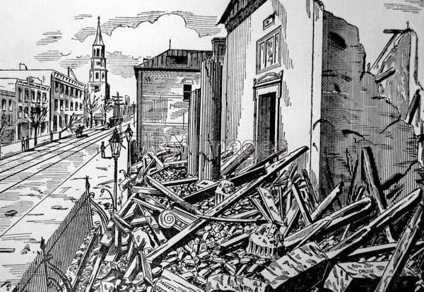    
Title: Earthquake, Charleston, S.C., 1886 Description: Widespread damage to buildings in the city, along with an estimated 100 plus persons killed and dozens more injured resulted from the largest quake to strike the southeastern United States; more than 2,000 buildings were destroyed or damaged at a cost of $6 million (the city's then entire structures estimated to be worth $20 million); damage occurred as far as Tybee Island, Georgia, sixty miles distant from Charleston and the shock waves were felt as far as Chicago, Bermuda, Boston and New Orleans; the quake was estimated to be between 6.6 to 6.3 on the modern Richter Scale and had a Mercalli Intensity of X; more than 300 aftershocks were recorded from this quake over the next thirty-five years, the main quake reportedly caused by the shifting of the Northern American Plate or an intraplate earthquake; Location: Charleston, S.C., August 31, 1886 Category: Disasters Topic: Earthquakes Keywords: aftershocks, disasters, earthquakes, intraplates, quakes Orientation: Landscape Dimensions: 1950 x 1342 (2.62 MPixels) (1.45) Print Size: 16.5 x 11.4 cm; 6.5 x 4.5 inches File Size: 7.50 MB (7,861,662 Bytes) Resolution: 300 x 300 dpi Color Depth: 16.7 million (24 BitsPerPixel) Compression: None Image Number: 0000060059 Source: Jay Robert Nash Collection |